
 |
| South Montague Sound. |
It was sad leaving Montague Sound but we were not even half way through the Kimberley and had to make haste. We set out and sailed north to the Prudhoe Island group, while Melita went west.
David and Lyndell had been to Prudhoe and Bigge Islands in 2013, so they decided as it was a very calm day they would attempt to take the 'short cut' between the mainland and Bigge Island, rather than spend days going around it.
The passage through Scotts's Strait is not to be taken lightly and it was the one we didn't want to do. The current is very fast so is best only negotiated at slack tide and in calm weather. It is also rock strewn mid channel so you can understand why we elected to go the long way around. David and Lyndell had been given guaranteed safe coordinates for the passage and thought since it was so calm they would give it a go. We just hoped we would see them in three day’s time at the planned rendezvous, Kartja Island.
 |
| Northern beach, Quoy Island. |
We
managed to sail at least half way to the Prudhoe Island group, but then the
wind died completely and we had to motor the rest of the way. Prudhoe and the
other two small islands, Quoy and Gaimard, are very dry and stark.
However, this
group does offer yachts the best offshore island anchorage on the coast. The anchorage is very well protected from winds and swell coming from the SW
quadrant through N and back around to the SE quadrant. They don't call it
Shelter Bay for nothing.
 |
| At anchor in Shelter Bay, looking south. |
 |
| Turtle tracks up to the nest. |
It also has some of the best beaches on which to roam, complete with turtle or crocodile tracks. Don't get these tracks wrong, an alternate pattern for crocodiles and a symmetrical one for turtles. Take your pick, but we knew which beach to land on.
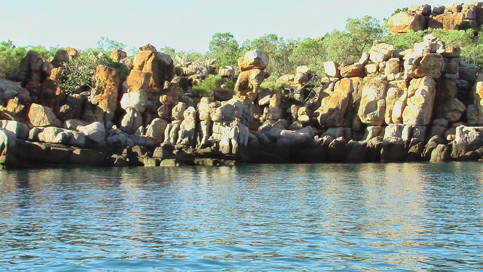 |
| The 'Council of Old Men'. |
We had this paradise all to ourselves - wonderful, so we spent a few days traversing the beaches and checking out the three islands by dinghy. The rock formations were also very interesting, and I christened one group "the council of old men" as that is what they resembled, sitting there in two rows of five.
On our
departure the winds were still minimal forcing us to motor the short distance
north and then west around the top of Bigge Island, in the Bonaparte
Archipelago. We then anchored in its most north-western bay, known as Wary Bay.
It is not a very good anchorage as you have to anchor a fair distance offshore
as the bay is filled with rocky outcrops due to its extensive fringing reef. No
snorkelling or diving here though due to the large resident crocodile. The bay
is also very exposed to the westerly wind and swell.
 |
| 'White man' at Wary Bay. |
beach. No walking for hours this time. The art depicted here is the well-known and photographed, Kaiara face and several images where the local indigenous people have recorded seeing European men. Unmistakable, sitting in their boats, with their large hats and their smoking pipes.
Later in
the day we sailed and anchored in a bay further south, known as Boomerang Bay.
A better overnight anchorage but still wind and swell exposed. Luckily for us
it was a nice calm night.
The next
day the winds picked up and we caught the current down the west coast of Bigge
Island and across the end of Scott's Strait and into York Sound. Twice during
this journey we had to radically adjust our course to miss two uncharted rocky
outcrops. The depth indicator suddenly alarmed and we dropped from 35m to 10m
depth in a matter of minutes. Both times we just ignored the sails and did a
complete 180 degree turn under power to avoid hitting what we thought would be
submerged rocky outcrops. Thank goodness we had set the alarms and managed to
get around safely by the time the depth indicator registered 5m. We then sailed
further west away from Bigge Island, before adjusting our course south again.
Crisis averted. Just remember if you are sailing south down Bigge Island, keep
the small group of rocks off the island to your port (left) and Tooth Rocks to
starboard (right).
Other
than the above hair raising minutes it was a pleasant and very quick sail south
to Kartja Island. It wasn't until we rounded the bottom of the Island that we
saw Melita safely anchored just off the beach, as the anchorage is in the south
east corner of the island. We pulled down our sails and started the motor just
as David in his tinnie pulled alongside. David had been out fishing most of the
afternoon on the reef that lies just off the beach and had bagged a few for
dinner. He showed us a deep hole away from the reef and we dropped anchor.
During
sundowners we all hatched a plan to take Melita into the large unnamed eastern
bay the following day to check out some caves and if the tides were right maybe
check out Rainforest Ravine. This large eastern bay in York Sound has not been
surveyed at all but again luckily for us David and Lyndell had the coordinates
from 2013.
We took Melita across the bay and once past the small Anderdon group
of islands we anchored in a little bay just to the east. This bay can be
affected easily by the westerly wind and waves but it is okay for a day
anchorage while you explore the caves. We then took the tinnie over to the
shore just before low tide.
There are four caves, each with a beach in front and a little headland separating them. You can walk around to each beach only at low tide and each cave is dry and accessible, but by half tide the caves are inundated. The northern cave is the best as it is quite extensive and has a resident bat population.
 |
| Each cave with headland and beach. |
 |
| Entrance to cave No.1. |
There are four caves, each with a beach in front and a little headland separating them. You can walk around to each beach only at low tide and each cave is dry and accessible, but by half tide the caves are inundated. The northern cave is the best as it is quite extensive and has a resident bat population.
We knew if we were going to visit Rainforest Ravine we would need several hours. Firstly, you need a rising tide to get up as far as possible by tinnie. Then it is also best to go 1 - 2 hours before high tide so you can return 1 to 2 hours after high tide, to safely access your tinnie. This way you have several hours to walk from the lower ravine to the upper ravine. Having to wait until lunchtime for low tide to see the cave system we knew it would be too late to see the Rainforest Ravine. At 6 pm it would be high tide and that meant walking back over boulders and submerged mudflat in the pitch dark. Even doing this without the threat of the large resident crocodile was too much. So we decided to abandon the plan.
 |
| Some exercise. Prince Fredrick Harbour. |
Instead an afternoon stroll around the beaches and rock formations of stunning Prince Fredrick Harbour did the trick.
 |
| Looking south. Prince Fredrick Harbour. |
No comments:
Post a Comment