
 |
| Anchored at Raft Point, with Steep Island to port. |
This part of the Kimberley has some of the biggest tides in the world and Collier Bay covers a huge expanse of water. So the sheer amount of water that rushes in and out with each tide is astounding and it creates a lot of disturbed water. Hence there are numerous eddies, overfalls and whirlpools that exists in this region.
We had a very quick and enjoyable trip down to Raft Point with the assistance of the flood (incoming) tide but as we got close to Steep Island and Raft Point we could see a lot of confused water up ahead. We quickly put down all the sails and turned on the motor as we were immediately aware that anchoring at Raft Point would be a challenge. Luckily we were heading into a strong breeze which did help us slow to some degree and we were nearing the end of the flood tide which wasn't propelling us south as quickly as it had previously been. Though it was still interesting getting through the whirlpools and eddies that exists between Steep Island and the mainland. Even with the motor going we would momentarily lose steerage and be taken for a ride wherever the water wanted to go.
Our visit to Raft Point also coincided with spring tides (higher high tides and lower low tides)
requiring us to anchor in 16m at high tide. When low tide finally did arrive we had dropped a whopping 12.2m in 6 hours and had only 1.5m of water under our keel. This was a record for us - the biggest tidal range we had ever experienced.
 |
| The spirit "Wandjina". |
That afternoon we checked out one of the three caves with indigenous art. The rest we would save for when we returned.
The weather prediction for the next few days was for very strong winds and not ideal for visiting Montgomery's Reef, one we would have to save for the return leg.
So the next morning we took the flood tide across Doubful Bay to Red Cone Creek. Accommodation was tight as every other boat in the region was seeking the same shelter, but we managed to squeeze in and had a very uncomfortable night.
 |
| Crossing Doubtful Bay to Red Cone Creek. |
The following morning we left the creek on the next ebb (outgoing) tide to get back to Raft Point. The winds had decreased a little but not enough to be comfortably anchored at Montgomery's Reef, so we decided that we would head for Melomys Island, en-route to Talbot Bay to see the famous Horizontal Falls.
This would require us to cross Collier Bay from east to west but the tides actually only help propel you either north or south. So we needed reasonably strong winds, from the east through the south, to overcome the pull of the tides.
 |
| Collier Bay - looking south to the mainland. |
 |
| Confused waters of Talbot Bay. |
I don't think either of us had been this worried and stressed out about doing a crossing before throughout the whole Kimberley trip. We gently motored into the passage and before we knew it, we were being flushed south, like through an 'S' bend'.
 |
| Catamarans, seaplanes and jet boats. |
Once down in Talbot Bay slack water finally arrived and we anchored near the permanently moored catamarans but out of the seaplane landing zone, and enjoyed evening celebrations for Peter's birthday. Most people coming to see the falls fly in by seaplanes from Broome for half or full day packages. But luckily they were not fully booked and we managed to squeeze onto one of the jet boats for the next day.
 |
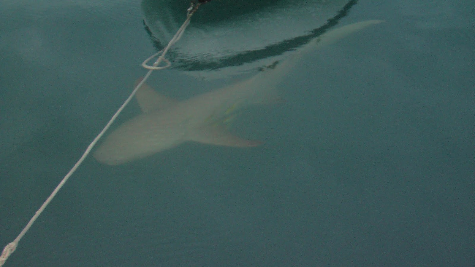
| Near blind Tawny Nurse Sharks. |
First up was the feeding of the Tawny Nurse sharks and then a tour of nearby bays. Finally the thrill we had been waiting for, a jet boat ride through the Horizontal Falls. We were told that we had arrived at a good time as the spring tides were still with us. Lower lows and higher high tides mean an increase in the drop between the falls.
 |
| The 1st pinch point in the escarpment. |
The Horizontal Falls are made up of two very tight and deep pinch points in the sandstone escarpment. On a flood tide (incoming) the Indian Ocean rushes into Collier Bay, then into Talbot Bay. Lastly it rushes through the two pinch points on the western side of Talbot Bay.
 |
| The 2nd pinch point. |
As you can imagine a lot of water has to squeeze into these two smaller bays through the very narrow openings each tidal cycle. So there is a time lag when the tide is higher in Talbot Bay and lower in the two smaller bays. Sometimes the difference between Talbot Bay and these smaller bays is up to 5m. Luckily for me on the day the difference was only 3m.
 |
| A huge whirlpool. |
The second opening is only 20 m wide but because of the erosive power of the water it is 40m deep. As the jet boat races through, it feels like you are riding down a steep water escalator.
 |
| The narrow pass is in the background. |
The next day we left Talbot Bay towards the end of the ebb tide to get a free ride out and into the adjacent Dugong Bay. This bay is again huge but the entry is even scarier and there is only word of mouth to help with the navigation.
There are four exceedingly narrow and treacherous entries to bays in the western Kimberley. Two are short cuts and therefore the less scary option is the route best taken. The other two are the only options, and if you want to visit you have go through them. One, Talbot Bay, we had just accomplished whilst adding a few grey hairs to our heads. The second, Dugong Bay, we were about to undertake but this time there was less room for error.
 |
| Very placid Dugong Bay. |
 |
| Spectacular Falls - now a trickle. |
Given the complexity of this treacherous path it can only be undertaken at slack water. Luckily there is an nearby anchorage one can take to await the slack water as any degree of flood tide would force you onto the rocks. This time we had timed our entry perfectly but it was still a scary adventure given the topography. At least this time we were able to go through very slowly at our own speed instead of being flushed down, through the 'S' bend.
 |
| Our only neighbour. |
Once through the passage the bay opens out and you realise just how beautiful it is. The water slows and the bay becomes like Lake Placid. The sandstone escarpment to the SE is at least 200m tall and the SW about 100m. There are also three waterfalls in the bay to explore. Given the time of the year two were dry and the 3rd was merely a trickle.
 |
| Dugong Bay at sunset. |
No comments:
Post a Comment